System Description
This document gives more extensive explanations and descriptions of the system and how it works. In addition, it offers a brief history of the basin and the web site as well as future developments on the Sevier River Basin Hydrologic Web Site. Its purpose is to give the viewer a better understanding and a more detailed overview of the entire basin and the automation behind it.
Introduction
The Sevier River Basin Hydrologic Web Site is the center piece of a system of communications links, computer servers, remote measurement devices, and water gate actuators which enable water managers in the Sevier River Basin to more effectively measure and control their water resources.
Sevier River Basin Description
The Sevier River Basin in south-central Utah is one of the State’s major drainages. A closed river basin, it contains approximately 12.5 percent of the State’s area—10,575 square miles (6.8 million acres). The terrain varies from high plateaus to narrow valleys and across broad deserts. Twenty-three percent of the region’s land is privately owned; federally controlled lands account for 69%, with state lands making up the other 8%. Indian tribal lands cover 1,735 acres of the basin. The basin is bounded on the east and south by the Colorado River Basin, on the west by the Beaver River drainage, and on the north by the Great Salt Lake drainage.
For the administration of water rights, the Sevier River Basin is divided into two major divisions, the Upper and Lower. The dividing point is Vermillion Diversion Dam, located east of Richfield.
 The Vermillion Diversion Dam, located east of Richfield, is the administrative dividing point between the Upper and Lower Sevier River.
Mountain ranges in the Basin trend southwest to northeast. Most are high plateaus, but there are some basin-and-range types in the northwest. Elevations range from 4,500 to 12,200 feet above sea level. Except where the river flows into the Sevier Desert, valleys are long and narrow.
[table w/images]
Average annual precipitation ranges from 6.4 to 13.0 inches in the valleys to more than 40 inches in the high mountains. Cold winters and mild summers result in growing seasons ranging from 60 to 178 days. Freezing temperatures have been recorded and can occur in every month of the year.
With such a wide variety of elevation, precipitation, and temperatures over the basin, there are several vegetative types that thrive in the area. In the higher mountains, a Conifer-Aspen forest supports white fir, Douglas fir, Ponderosa pine, spruce, and quaking aspen trees. The second type of vegetation the basin supports is Mountain Brush. This category includes gambel oak, seviceberry, and curlleaf mountain mahogany. Pinyon-Juniper vegetation is found in the foothills, between elevations of approximately 5,500 ft and 7,500 ft. Examples of this vegetation type are; pinyon pine, Utah juniper, shrubs, grasses, and forbs. The valleys contain mostly Northern Desert Shrub vegatation, plants such as Indian ricegrass, needle and thread grass, winterfat, black greasewood, and shadscale. These tend to thrive in areas where the soil is affected by salts. The final vegetation category the Sevier River basin supports is Sagebrush, which can be found at nearly every elevation.
The population of the Basin was more than 56,700 people in 1997, with most of the populace residing in small farming communities. The population of the basin is expected to reach over 86,000 people by 2020 (based on the current annual growth rate of 1.82%). Richfield (6,500 residents at the beginning of 2002) is the largest town. The economy of the Basin is based primarily on agriculture. Other important economic activities include tourism and a few mining and manufacturing enterprises; including the 1,600-MW Intermountain Power Project near Delta.
Principal Water Sources
Physiography and Geology
The Sevier River once terminated in ancient Lake Bonneville just south of present day Gunnison; with all of the Sevier Desert and Pahvant Valley under water. As Lake Bonneville receded to the north, the Sevier River drained into the Great Salt Lake by way of an old channel located north of Delta. More recently the Sevier River was joined by the Beaver River and flows into Sevier Lake, a dry playa which receives water only on the wettest years.
As mentioned above, the Sevier River once entered prehistoric Lake Bonneville near Gunnison. Today, any remaining water not consumptively used is discharged into Sevier Lake. Since the turn of the century, irrigation has depleted the river and only occasional floods, like those in 1983 and 1984, and some irrigation return flows reach Sevier Lake.
Major Streams
Major streams in the basin include the main stem of the Sevier River and its tributaries: the San Pitch River, the East Fork Sevier River, and Otter Creek. Agricultural return flows are an important component of the Sevier River. Fifty percent or more of the total tributary and river diversions reappear as return flow downstream.
Headwaters of the Sevier River are in the Markagunt and Paunsaugunt Plateaus of south-central Utah. The river generally flows northward to just below the Sevier Bridge (Yuba) Reservoir, where it turns to the northwest and then southwest through Leamington Canyon. From the main stem near the town of Hatch, the river flows 225 miles before it reaches Sevier Lake. The river is regulated by reservoirs and irrigation systems.
The Sevier River and its tributaries constitute the major sources of water for agriculture in western Garfield, Piute, Sevier, Sanpete, Millard, and southeastern Juab Counties.
Groundwater
The basin above the Sevier Bridge (Yuba) Reservoir is characterized by a series of groundwater reservoirs, each seperated from the one upstream by a relatively impermeable, underground geologic restriction. These groundwater sources have a storage capacity that is estimated to be about 5.5 million acre-feet (source: U.S. Geological Survey). Groundwater tributary yield is estimated at 20-25% of the surface water yield. Average withdrawals from groundwater are 155,450 acre-feet annually.
Cloud Seeding
In recent years, the U.S. Bureau of Reclamation has installed cloud seeding machines in the mountains seperating the Sevier River Basin and the Emery Water Conservancy District, in an attempt to increase the amount of water being stored in the reservoirs. While these cloud seeding machines are primarily intended to help reservoirs and rivers in the Emery district, there is probably some residual benefit to the Sevier River. The machines are located in the San Pitch region (part of the Sevier River basin) and rely on the wind to carry the seeding material and results over the ridge and into the water supply for Emery county.
Reservoirs
The three largest storage reservoirs in the Sevier River Basin (Otter Creek, Piute, and Sevier Bridge {Yuba}), account for about 75 percent of the total storage capacity. The combined capacity of the remaining reservoirs is approximately 120,000 acre-feet. These smaller reservoirs are used exclusively to store irrigation water, and some contain water only in years of excess precipitation. Several are extremely inefficient and lose considerable water through evaporation and seepage.
Table 1. Major Reservoirs in the Sevier River Basin
table{width:600px; height:150px; border:1px solid black;}. |<. Reservoir |<. Water Source |<. Use [1] |>. Capacity(acre-feet) |_>. Surface Area
(acres) | | Otter Creek | East Fork Sevier River |IR, R |>. 52,660 |>. 2,520 | | Piute | Sevier River |IR |>. 71,830 |>. 2,508 | | Sevier Bridge | Sevier River |IR, I, R |>. 236,150 |>. 10,905 |
1 Primary use of stored water: IR = Irrigation, I = Industrial, R = Recreation
Water Usage
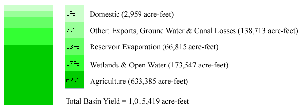
Agriculture accounts for the single largest use of water in the basin (61 percent). In 1997 total diversions for irrigation were 903,460 acre-feet. Secondary irrigation used 8,590 acre-feet. In that same year the use of secondary water ratio was 153 gallons per capita per day, which is significantly higher (and better) than the state average of 50 gallons per capita per day.
Due to the lack of large population centers, domestic use before the turn of the century accounted for less than one percent of the total. Domestic use has been increasing in recent years, with culinary use diverting 23,360 acre-feet in 1997. Drinking water is projected to become an issue in the near future. Currently the basin-wide use of culinary water is 267 gallons per capita per day. Millard County and Juab County had especially high rates, 357 gallons per capita per day and 415 gallons per capita per day, respectively.
Industrial use also accounts for 26,290 acre-feet of diversions. The Intermountain Power Project is currently diverting approximately 20,000 acre-feet of water from agriculture in the Delta area. There are a total of 12 hydroelectric power plants operating within the basin boundaries.
Table 2. Annual Water Usage
Water Quality
The best or highest water quality is found in the “upper” region of the Sevier River. At the lower end of the river, salinity is a major problem. The www.sevierriver.org web site currently displays information from three different salinity sensors located in the lower region of the basin. Some salinity issues are due to erosion, caused by overgrazing in the upper regions. Efforts have been made and are continuing to be made, to help improve the water quality throughout the river. In recent years, $375,000 was expended on the Otter Creek Reservoir watershed to implement best management practice in an attempt to improve water quality.
Water Development
Development of the Sevier River system is a tribute to the stamina, ingenuity and independence of early water users. Using comparatively crude implements, they excavated hundreds of miles of irrigation canals and constructed Gunnison Bend, Otter Creek and Sevier Bridge (Yuba) Reservoirs. The State and Federal governments had some involvement in the Piute and Delta projects, but it was chiefly the water users who developed the Sevier River water system. In so doing, they transformed much of the desert wilderness of south-central Utah into productive farmland.
Early Development
From about 1850 to 1890, water users relied on direct diversions from the river and its tributaries for irrigation. Until the early 1890’s, natural flow, along with the stabilizing effects of irrigation return flows, yielded enough water for most of the irrigated acreage. Heavy snowpack provided abundant water in the winter and spring, but not in late summer when crop needs were greatest.
Because it was prohibitively expensive to construct storage dams, settlers often depended solely on low diversion weirs to dam a creek or river. The geological features at a few locations such as Gunnison Bend in the lower Sevier River Basin were suited to construction of an impoundment reservoir, but most storage dams were not constructed until the 20th century.
Otter Creek
Construction of Otter Creek Dam and Reservoir was prompted by dry conditions during the 1890’s. Prior to building the dam, the reservoir company obtained options on ranches along Otter Creek that would be inundated. Robert Dixon Young, a prominent Richfield resident, volunteered to oversee construction of the reservoir, and ground was broken in 1897. Skeptical State officials doubted that the financially strapped company could complete the project. Construction was also hampered by a lack of equipment, difficult working conditions, and a lack of local support.
Interest in the project increased when crops in Sevier Valley were saved with water impounded by the partially completed structure. Most of the dam was completed by 1901, though work continued for several years on the outlet works, spillway, and feeder canal.
Sevier Bridge Reservoir
In 1902, a surveyor hired by the Deseret Irrigation Company recommended a site at Sevier Bridge (Yuba) in Juab County for a reservoir to impound unappropriated water from the Sevier River. Shortly thereafter, the State Engineer approved plans and specifications for a dam 60 feet high. Construction was funded by a $5 assessment against each share of stock in the irrigation company, and a stockholder could work off the assessment at the rate of $2.50 a day for one man and a team of horses. Nearing completion, the earthen dam was compacted with wagon wheels. But, in 1907, runoff on the Sevier River nearly washed out the incomplete structure. The dam was completed two years later, but because the structure’s cutoff trench was inadequate, water from the reservoir percolated under the dam, causing seepage problems.
Four irrigation companies in the Lower Sevier Basin enlarged the Sevier Bridge (Yuba) Reservoir and corrected seepage problems. The enlarged dam-90 feet high-was the largest dam constructed in Utah, using hydraulic methods. Most of the work was done by stockholders of the Deseret Irrigation, Melville Irrigation, Delta Land and Water, and Sevier River Land and Water companies, under the direction of consulting engineers. The enlarged structure was completed June 17, 1916.
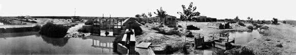 Area northwest of Delta, circa 1915, with its newly constructed irrigation system.
Piute Reservoir
The State of Utah funded water and land projects with money from the sales of Federal lands, and after constructing the water facilities sold irrigable land downstream from the reservoirs. The Piute Dam and Reservoir were constructed to service the Sevier and Gunnison valleys. A canal 65 miles long was then constructed along the western valley bench to deliver water to 20,000 acres. Land sales in the area were promoted in the eastern and midwestern United States. Among those attracted to the area was the short-lived Jewish Agricultural and Colonization Association. Local water users struggled with financial problems for many years, until the State finally turned the project over to them.
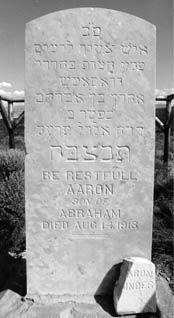 Tombstone of Aaron Binder, agricultural colonist. The Gravesite, located west of Centerfield, is mute evidence of the Jewish Agricultural and Colonizational Association.
Water Rights
Water rights in the Sevier River Basin consist of two types: primary or streamflow rights and storage rights. Storage rights are entitlements to water that is not usable for irrigation by direct diversion, e.g., winter runoff, floodflow, and water returned by those holding the primary right. Most of the conflict over water in the Sevier River Basin involves distinctions between these two types of water rights.
By 1890, all the land along the Sevier River that could be served by direct flow was under cultivation. One spring, after no water reached the town of Deseret, residents were so angry they hired a posse in an unsuccessful attempt to remove upstream dams. The Deseret and Leamington Irrigation companies subsequently filed a successful lawsuit to establish their water rights.
Higgins and Morse Decrees
In 1901, Judge Higgins resolved the conflicting claims by issuing what has since become known as the Higgins Decree. His decree (1) used the pro rata method of determining equitable water allocation, and (2) determined that legal action along the Sevier River should not be limited by county boundaries. The decree also established a common priority for users in the Lower Basin. In 1906, Judge Morse also used the pro rata method to determine the supply of water from the headwaters to Vermillion Dam. However, because funds were not available to hire a river commissioner, the Higgins and Morse Decrees never had any significant effect.
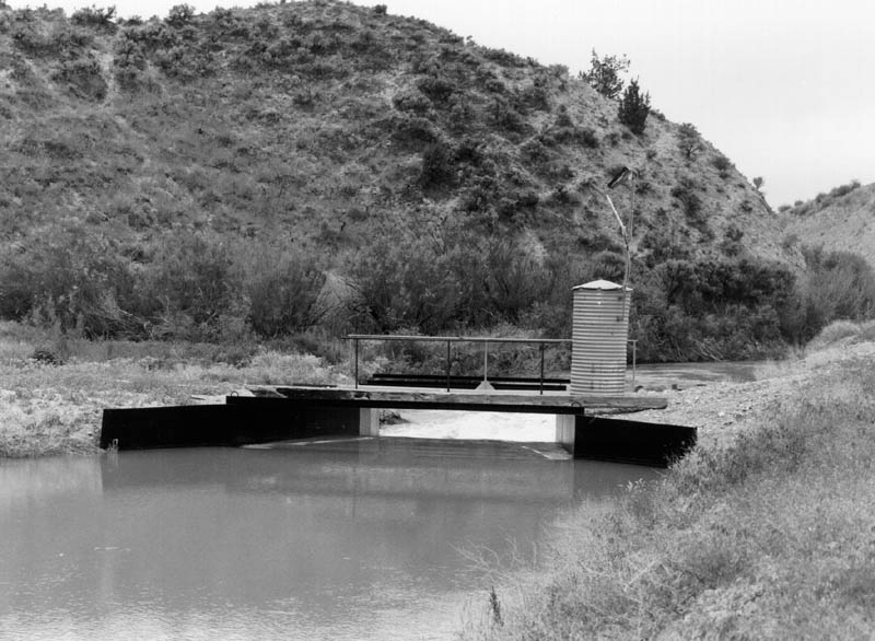 Gauging station on the Lower Sevier River used by the river commissioner to manage water supplies.
Cox Decree
In the absence of effective river management, disputes continued throughout the Basin, the most difficult being the division of water between the Piute and Sevier Bridge (Yuba) reservoirs. In 1916, the Richlands Irrigation Company brought action against various Lower Basin interests to adjudicate its claimed rights. The cost of litigation associated with the dispute exceeded $350,000. Because the costs of resolving the more than 750 remaining claims was likely to exceed the value of land and water, regional committees were formed to resolve these issues. Most of these committees adopted, by stipulation, the existing Higgins and Morse Decrees, and eventually succeeded in reaching a decision in the Richlands action, which is now known as the Cox Decree.
The Cox Decree did not eliminate or even diminish water conflicts in the Basin. Even though it helped define individual rights in local areas, it was much less specific about the allocation of water rights over the length of the river. In addition, the Cox Decree is a legal document and not an operation plan. As a result, the river commissioners who began administering the river in 1934, under the direction of the State Engineer, had to interpret various provisions of the decree.
The Cox Decree finalized in 1936 was the final determination of all the water rights. Although there have been modifications to this decree, it is still in use today.
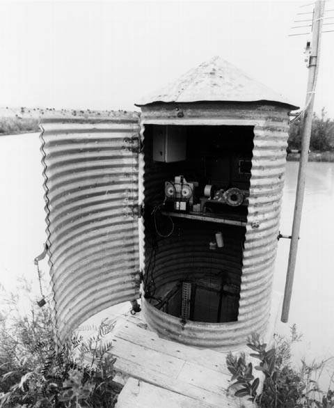 Inside the stream gauging station.
The 1938 Agreement
The 1938 Agreement was one of the most important documents to influence water use along the Sevier River because it (1) allowed companies to hold over any unused water and (2) allowed Piute to exchange their primary rights in the lower zone.
Before the Agreement, all of the unused water in the Sevier Bridge (Yuba) Reservoir remaining at the end of the irrigation season was forfeited and redivided at the start of the next irrigation season, which encouraged wasteful practices. The 1938 Agreement allows each irrigation company to retain ownership of its unused, year-end supply. The irrigation companies in turn, allow each stockholder to hold over his/her unused annual allotment. The holdover practice stabilizes the water supply from year to year by allowing the Sevier Bridge (Yuba) Reservoir to operate as a long-term carryover reservoir. Under these conditions, a user cannot afford to divert water except for sound economic reasons.
Implications
Enhanced management in the Sevier River is facilitated by (1) the concept of pro rata division introduced by the Higgins Decree of 1901, which ensures that all irrigation systems are in place to utilize water when water is plentiful; (2) the ability to treat water rights as personal property, i.e., water can be bought, sold, and used as collateral, just like land, homes and automobiles; and (3) the 1938 Agreement, which helped stabilize the water supply from year to year. As a result, the water supply is stable, and water can flow to the most beneficial use. During drought, only the most productive land is irrigated. The system also provides for long-term changes in water use, e.g., the acquisition of 45,000 acre-feet of water by a power company.
Canal and Reservoir Automation History
GOES Real-time Monitoring System
In the late 1980s, GOES (Geosynchronous Operational Environmental Satellite) technology was used on river and canal monitoring stations along the Sevier River. These stations, which provided data on an hourly basis, demonstrated the usefulness of real-time information for improving management of the river. The problems with the initial system were two-fold: (1) the communication system was one way and thus not suitable for most control applications, and (2) the system for distributing the data was primitive, each river commissioner had his own satellite downlink station, hence, the data was not widely distributed.
Delta Area Canal Automation
In 1991, the Delta Canal and Melville Irrigation Companies in the Lower Basin asked USU and Reclamation to develop and install a system to control the flow of water through Canal A, which supplies water to the two companies. The system was developed and installed by engineers through USU’s Biological and Irrigation Engineering Department (Walker, 1993). The canal automation system included: (1) a radio-telemetry network that transmits data and commands; (2) a datalogger/controller that collects data about gate positions and water levels, as well as raises and lowers gates; and (3) a microcomputer that controls the system.
The aim of the Canal A automation project was to reduce losses while maintaining a high degree of on-demand flexibility in the canal’s operation. The system was designed to improve regulation through easier and more timely changes in gate openings, better flow measurement as a result of more stable outflows, and automatic regulation during periods when the canal was unattended. The project proved successful, producing a water savings of 3,000 acre-feet in 1993, its first full year of operation.
Richfield Area Canal and Reservoir Automation
After viewing the success of the Delta project, irrigators in the Richfield area opted to try components of a selective automation system. During 1993, in a joint effort with Reclamation, the Richfield Irrigation Company installed a radio-telemetry monitoring station on the Parshall flume at the head of their canal. The station allowed the water manager to observe conditions and improve canal operations. After a year of monitoring canal flows, the company decided to upgrade to real-time control.
During the early Spring of 1994, the telemetry equipment and controller were moved 200 feet from the flume to the diversion structure. Subsequently, the gates on the diversion structure were motorized with solar-powered DC motors, and the datalogger/controller was reprogrammed for manual remote control. This enabled the water manager to make gate changes from his residence. Richfield’s new system proved to be a useful water conservation tool (Pugh and Hansen, 1995).
During 1995, the Richfield diversion structure was equipped with automatic remote control. This was accomplished by installing enhanced software at the field site. Now instead of moving the gates by remote control, the water manager could set a canal flow target remotely and the gates automatically move to maintain the require flow. The canal manager estimates that the system has helped the company conserve approximately 12 percent of its water supply.
After the success of the Richfield Canal automation project, Reclamation assisted seven other canal companies in the Richfield area to automate their structures. Both major reservoirs serving the area (Piute and Otter Creek) were also automated. In addition, there were 15 real-time river and canal flow monitoring sites. Since 1999 there have been several sites added to automate the entire basin. All data communications in the area are via a combination of VHF radio and telephone equipment (Hansen and Pugh, 1997).
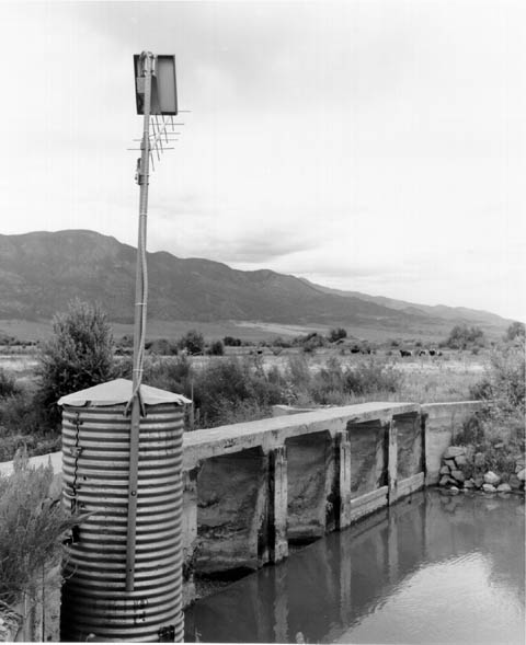
This site-the Richfield Canal Diversion Dam on the central Sevier River-is fully automated. The 3 main gates automatically move up and down to maintain a target flow, as measured through the flume located just down the canal from the dam. The flow targets are transmitted to the site and the flow data is sent to the canal manager by radio telemetry.
To automate the diversion structure, the 3 gates were retrofitted with fractional-horsepower 12-Volt DC motors, gate position sensors, and limit switches (see photograph that follows). Other equipment at the site includes a remote terminal unit, telemetry radios, and a float-and-pulley potentiometer system to measure water depth in the well adjacent to the flume. The system is low cost and powered by solar energy.
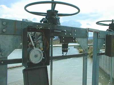 Photograph – Low-cost gate actuator: The box left of the gate stem contains the gate position sensor and limit switches. On the right of the stem is the 12-Volt DC motor. Both units are attached to the gate stem with a sprocket and chain.
In 1998, a digital camera system was added at the site. This system sends an updated digital image-via spread-spectrum radios-to the Internet every 10 minutes.
Automation of the Entire Sevier River Basin
Since 1999, automation equipment has been installed and is currently collecting data at stations throughout the entire basin. The site has expanded to include sensors on reservoirs, canals, diversions, and the river itself. Currently there are six weather stations in addition to flow sensors. The site also links to several cameras, some of which can be user controlled—zoomed in and out as well as pan the area. All of these items will be covered more extensively in the WebSite: www.SevierRiver.org section.
Evapotranspiration is another area that has been expanded in recent years. After gathering and processing data from the weather stations located in the basin, programming code calls a program that calculates and then displays evapotranspiration data for a number of different crops on a daily basis. This aides farmers and homeowners in knowing the amount of water their crops and lawns need. This is part of the weather section that will be covered later on.
Web Site History
The various monitoring and automation systems in the Sevier River Basin were generating substantial amounts of data, but it was unavailable to all but a few water managers. This was a constant source of frustration to a number of water managers who needed the data to improve their operations.
Meanwhile, the rapid rise in the development and use of the Internet meant that many of the water managers were either getting “on-line” or considering it. It became apparent that getting the real-time data onto the Internet might become a good way to distribute the data to a wide audience without requiring the water users to purchase specialized equipment.
In 1997, StoneFly Technology approached the water users in the Upper Basin with a proposal to connect their real-time database to the Internet. This proposal was accepted and Reclamation agreed to assist with the project. That fall, a preliminary web site was tested and well received. The site was expanded for the 1999 irrigation season and the graphic displays were enhanced.
At their annual meeting in January 1999, the Sevier River Board enthusiastically endorsed a proposal to expand the web site to include the entire Sevier River Basin. At the end of 1999, the web site began presenting an accurate real-time representation of conditions throughout the Basin. Any water manager or interested individual is able to sit down at a computer and survey hydrologic and weather conditions throughout the region.
Sources
- Arrington, Leonard J. 1951, “Taming of the Turbulent Sevier: A Story of the Mormon Desert Conquest.” Western Humanities Review (26:1) University of Utah, Salt Lake City, UT. NOTE: Arrington’s work is viewed with some suspicion by local historians.
- Goldberg, Robert Alan. 1986, “Back to the Soil: The Jewish Farmers of Clarion, Utah and Their World.” University of Utah Press, Salt Lake City, UT.
- Walker, Roger. 1997, “Gunnison Bend Reservoir” Unpublished.
- Walker, Roger. 1985, “The Delta Project: Utah’s Successful Carey Act Project.” Unpublished.
- Young, Revo M. 1985, “Robert D. Young and the Otter Creek Reservoir.” Utah Historical Quarterly (53:4) Utah Historical Society, Salt Lake City, UT.